Hurricane Dennis Watch 2
Posted by RazorsKissJul 10
Update: 10:25am

Dennis can’t decide what it wants to do – but it sure looks mean.
Update: 9:55am
Sorry about the time between updates!
I went to get a drink… I HAVE been up all night, and all.
It seems like Dennis has decided to jog a bit back toward the northeast, which is putting it on a track to even miss Mobile entirely. I hereby relinquish my prediction for Pascagoula.
The Florida panhandle (yet again) is going to get absolutely creamed, instead. Sorry, Florida – it wasn’t our idea, we promise! It’s now headed N/NW at 18mph. Projected track puts it between Mobile AL and Fort Walton Beach FL, as of right now. Offshore waves in excess of 30 feet – I’ve seen several reporters saying they’ve seen coastal waves nearing 20 feet.
The eyewall, where the most damaging winds occur, is projected to cut a swathe 25 miles wide – with a truly scary northeastern quadrant. That means that places like Destin are going to be Dennis’ punching bags, unfortunately.
Keep watching for further course corrections from Dennis, though – it’s done a bit of moving thus far – another wouldn’t surprise me.
Winds at 140 mph, 940mb.
Ugly stuff. Keep checking it out, and keep a close eye on it. In the meantime, I’ll do another map, I think.
Last post was full, more or less, so this is a new post – and it will have a few hours worth of updates here, too. And playing with Google Earth maps. May as well learn the software while you keep people informed, hrmm?
Hancock, Harrison, and Jackson counties, MS – evacuation orders for all low-lying areas. A, B, and C. Harrison reminds you that evacuation is a matter of life and death for residents in those areas. That means you. Get out, now.
Go to the
MS Emergency Management Agency Information page for more info, MS residents.
It’s still steadily heading towards the Alabama coast – which means that it could still hit just about anywhere within the “danger zone” still – as the Alabama coast isn’t very long. So, Florida to Mississippi.
Wind speed remains at 145 mph.
We’re looking at a max of 12 hours before this storm hits – and I seriously doubt it will be that long. The weathermen are saying it’s going to hit around Mobile, still, and are even edging toward Pensacola. I may, in fact, be wrong about my Pascagoula prediction.
But I may not. Regardless, those who remember Ivan can surely tell you – a storm like this will definitely be felt as far as that – and likely into Gulfport/Biloxi, to crushing effect. Ivan, if you also remember, was a Category 3 hurricane – this one is a Category 4. The effects will be more severe, and it’s cutting to the west as it approaches – which means it’s going to bury itself deeply into southwestern Mississippi, and into central Mississippi as well.
Mobile is going to get hammered, and so is Pensacola, regardless of where the eye makes landfall. The northeast quadrant is the doozy – and even if it veers decidedly westward, it will hammer those two. So they’re going to get it regardless. The eyewall, where the most damaging winds are to be found, looks to be able to cover a good 50-60 miles across. At least. I’m about 60 miles from Pascagoula, as you may recall from last post. I am 90 miles from Mobile.
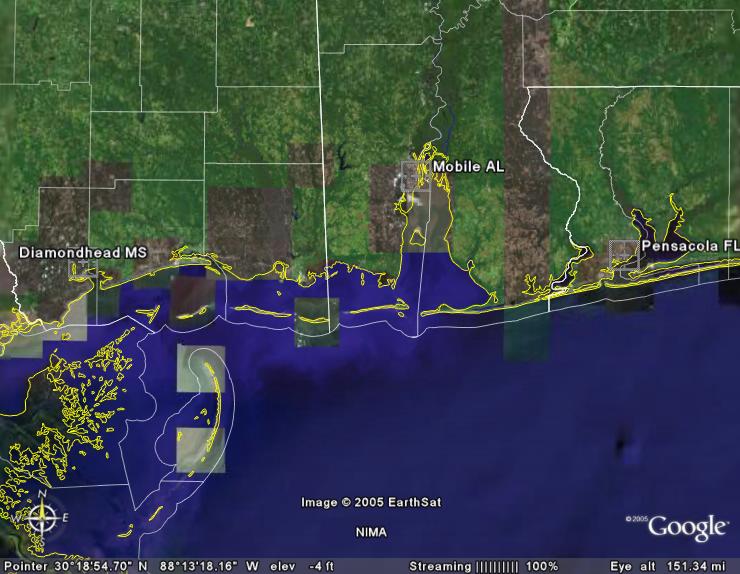
Click image for full-sized picture in a new window.
So, over to the left is where I am. Pensacola is to the right. Mobile is centered, more or less.
Now, for where Dennis is, in comparison.
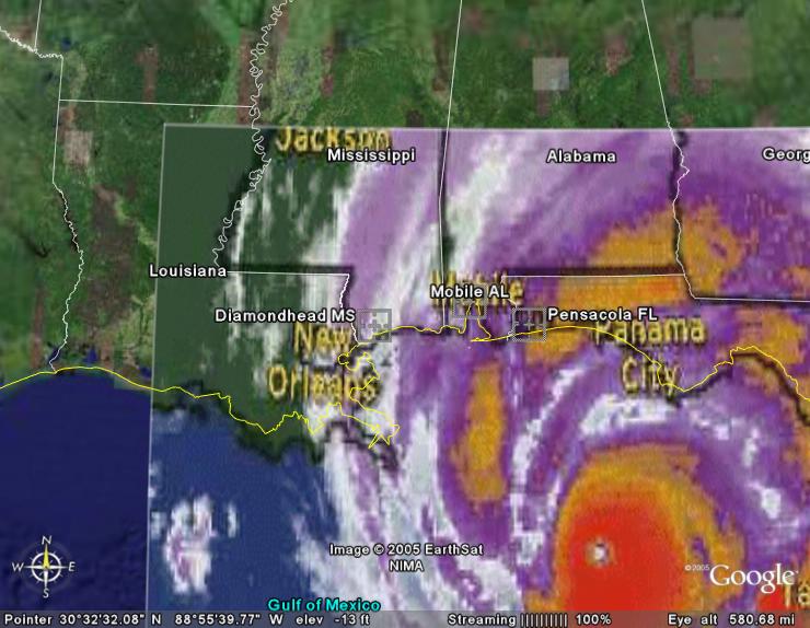
As you can see, in this overlay, the main body of the storm is wide enough to cover the entirety of the Alabama coast. And the Mississippi coast too, I do believe. That means that even if you “miss” the center – you’re still going to get knocked a good one. So, if it hits Mobile, dead on, Pensacola is going to get creamed even worse, as it’s farther east, and I’m going to likely get the edge of the main body myself – or pretty close to it.
So, that tells you – this is a BIG storm. It’s a Category *4*.
I mentioned earlier that they are edging toward predicting a Florida strike. That is because the course of the hurricane seems to have jogged slightly in that direction in the past few hours.
930 mb, N/NW @ 15mph.
That pressure is the lowest yet recorded by this storm – which is bad, incidentally.
Technorati: Hurricane Dennis
2 comments
Comment by Bethany on July 10, 2005 at 8:36 am
Well, I won’t fuss at you too much, since you can sleep later when the electricity goes out! 😀
Pingback by A Picturesque Life :: Life in Pictures » Waiting for Dennis on July 10, 2005 at 9:05 am
[…] th. So…to keep up with the progress of the infamous Hurricane Dennis check here and here. And…if you are in the pan handle of Florida or the coast of Alabama or Mississippi, be careful and s […]